Free Download Aquaveo Groundwater Modeling System (GMS) 10.9.4 | 1.9 Gb
Aquaveo, a water resources consulting company, is pleased to announce availability Groundwater Modeling System (GMS) 10.9.4 is the most advanced software system available for performing groundwater simulations in a three-dimensional environment.
The Groundwater Modeling System (GMS) has made a slight change in version 10.9 to how we model MODFLOW 6 to make modeling more efficient for you. Now, in GMS 10.9, the Map from Coverage command has moved directly into the package dialog. This means no more jumping back and forth between windows; you can map your data right where you're working.
What's New in GMS 10.9.4 - Date: March 10, 2026
Import
- 16002 GMS crashes when importing MODFLOW-USG model
- 16023 GPR Corruption
Simulation
- 16007 HGS BC Points Aren't Snapping to Ugrid Node Locations
Display
- 15834 Refining a Ugrid Fills in Pinchouts with Thin Cells
- 15839 Display of "Through Cells" is Inconsistent On MF6 Ugrid
- 16018 Background color does not change right away
MP3DU
- 16016 Batch Run Doesn't Work With MT3D-USGS
SEAWAT
- 16024 SEAWAT crashes if MODFLOW is steady state
Hyrdro-AS
- 16015 Running Grok for HGS Inside of GMS Erases Manual Changes to Some Files
- 16027 Deprecated HGS Feature: "Potential Evaporation Using Transpiration"
MODFLOW
- 16008 Using Clusters for Parameters with the UPW package Doesn't Show Layer Information
UGrid
- 16006 Created Ugrid does not have Point Z Dataset
MODFLOW6
- 15975 Cell Properties Menu for MF6 Doesn't Show the Data Until You Click a Different Package, and Then Go Back
Undefined
- 16043 GUI Test: GMS Crashes when Selecting Ortho mode
RT3D
- 16036 Using Runge-Kutta Solver in RT3D Stops Model Run From Initializing
Toolbox
- 16055 GUI Test: Python crashes when closing Ugrid from Coverage dialog
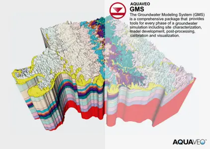
TheGroundwater Modeling System (GMS)is a comprehensive graphical user environment for performing groundwater simulations. The entire GMS system consists of a graphical user interface (the GMS program) and a number of analysis codes (MODFLOW, MT3DMS, etc.). GMS was designed as a comprehensive modeling environment. Several types of models are supported and facilities are provided to share information between different models and data types. Tools are provided for site characterization, model conceptualization, mesh and grid generation, geostatistics, and post-processing.
GMS
Instructional videos for the Groundwater Modeling System (GMS) program developed by Aquaveo.
Aquaveois a pioneer of GIS-based software solutions for hydraulic, hydrologic and groundwater modeling. Our products have been refined over two decades to create the most advanced environmental modeling and visualization software available. In addition to interfacing with industry standard numerical models, we develop custom desktop and cloud-based applications tailored to specific needs. Aquaveo began as a part of the Engineering Computer Graphics Laboratory at Brigham Young University in 1985. The lab was reorganized and the name was changed in September, 1998 to the Environmental Modeling Research Laboratory (EMRL). In April, 2007, the main software development team at EMRL entered private enterprise as Aquaveo, LLC.
Owner:Aquaveo
Product Name:Groundwater Modeling System (GMS)
Version:10.9.4
Supported Architectures:x64
Website Home Page :
Code:
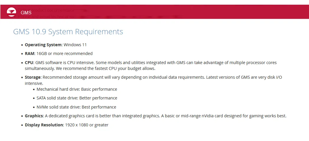
www.aquaveo.comSystem Requirements:Windows *
Size:1.9 Gb
Recommend Download Link Hight Speed | Please Say Thanks Keep Topic Live
Rapidgator
ikex1.Aquaveo-Groundwater-Modeling-System-GMS-10-9-4.rar.html
DDownload
ikex1.Aquaveo-Groundwater-Modeling-System-GMS-10-9-4.rar
FreeDL
ikex1.Aquaveo-Groundwater-Modeling-System-GMS-10-9-4.rar.html
Links are Interchangeable - No Password - Single Extraction